Recently, my family and I took our annual vacation to the South Carolina coast and the beautiful city of Charleston. This year, we decided to take a horse-drawn carriage tour and take in all the history and stunning architecture of this port city. Charleston, being one of the oldest American cities, is a striking example of the continual evolution and adaptation of our urban centers to meet natural and man-made challenges. As an example, much of modern-day Charleston is built upon land-filled edges of the peninsula, which has grown over time to accommodate a growing population. Like other US colonial cities, the roads were clearly also designed with horses and buggies (not cars and buses) in mind.
As I traveled the city, it really got me thinking about the development process that architects, urban planners, and civil engineers must go through in order to cope with an ever-changing populace and environmental landscape. The reality of man-made climate change has accelerated the need to make more educated, data-driven decisions to drive sustainability and survivability. This is particularly true along coastal areas due to high winds and sea levels, especially during major hurricanes. Computer simulation is playing a major role in informing this early-stage decision-making process and enabling AEC professionals to develop smarter and more efficient cities and structures.
Urban Microclimate Modeling Using SimScale
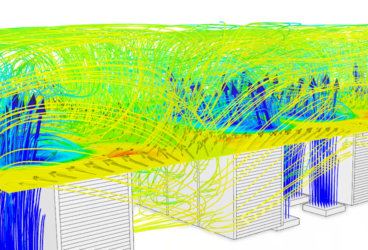
For now, we will focus on the problem of dealing with the effects of wind, setting aside water management for a future post. In order to understand the detailed effects of wind on structures and urban areas, the AEC industry has increasingly turned to advanced computational simulation (CFD) tools. Historically, these software packages require a large investment in hardware, licensing, and expert personnel to deploy. SimScale has changed this paradigm by offering an intuitive browser-based platform to conduct high-fidelity wind comfort CFD simulations entirely on the cloud.
The SimScale platform has been adopted by leading global AEC firms to utilize the Pedestrian Wind Comfort (PWC) approach during early stage design. Learning about your design early rather than later in the cycle and mitigating issues is the objective. Upfront in the process, you have more opportunities to correct problems, but the challenge is often in having realistic data to identify these problems. SimScale PWC modeling can solve this paradox by providing realistic wind behavior in advance.
Our Case: Boston Common Microclimate Simulation
To illustrate how SimScale PWC is used in the early-stage design process, refer to the below Boston city data imported from bostonplans.org. The building of interest is highlighted.
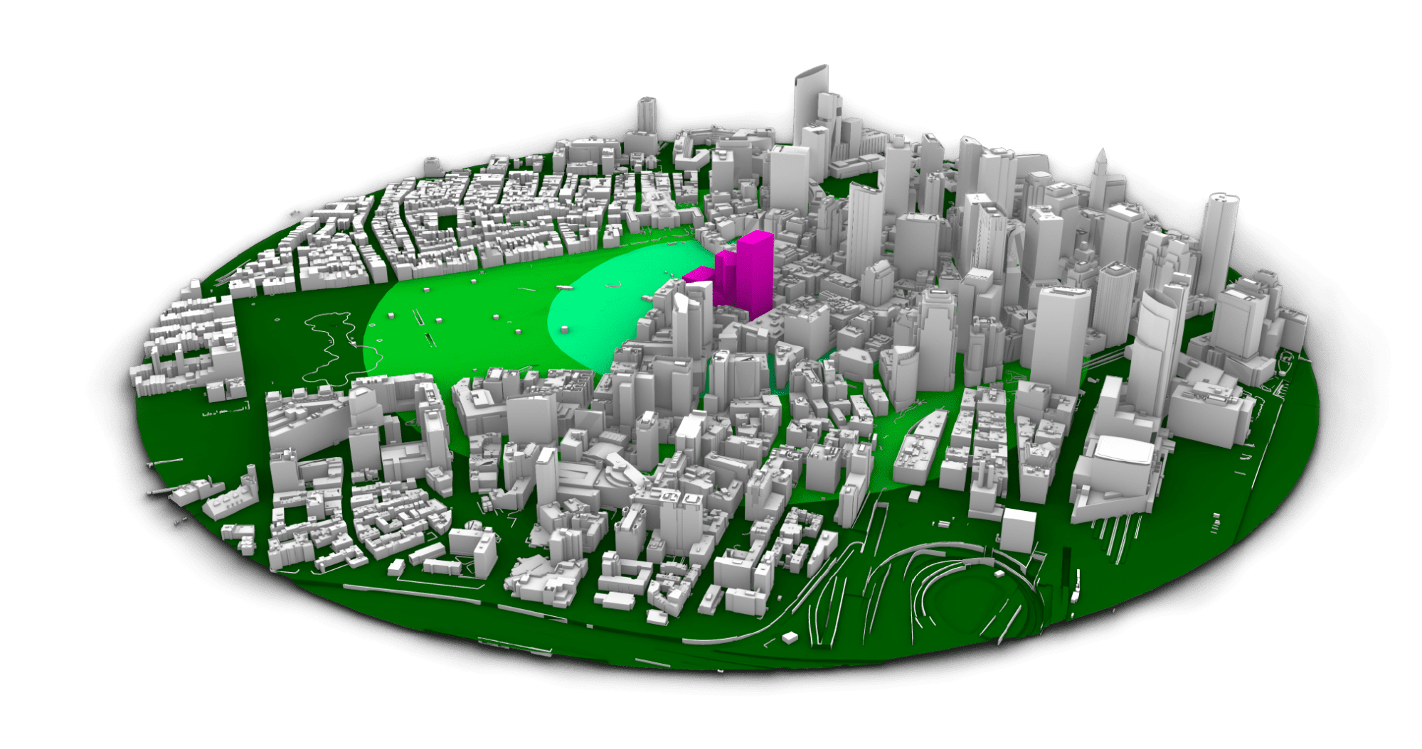
The objective of this early-stage study could be to identify the site layout/orientation, building and feature heights, optimal activity areas based on wind comfort, and problematic or dangerous areas due to high winds.
Thanks to the robustness of the SimScale PWC approach, this geometry did not require any cleaning and is ready to simulate after a small topology extension is applied at the periphery as per our best practices. Because the SimScale PWC solver is based on a fast, cloud GPU method, results for all wind directions can be returned in 1-2 hrs. Additionally, many designs can be tested at once in parallel.
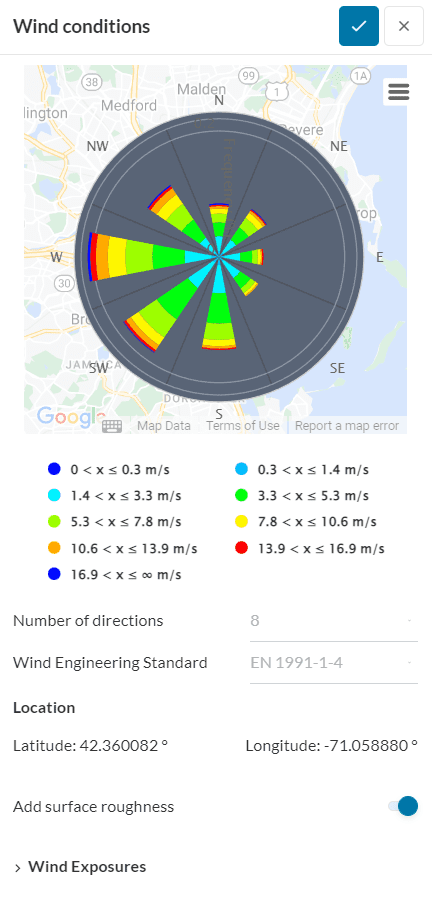
All of this computational power would be useless if it was not easy for the PWC professional to set up and run. Thankfully, the PWC workflow is tailored and guided for non-expert users, with a simple guided process and advancements such as a built-in wind calculator leveraging data from meteoblue. If you are a more advanced user, the UX does provide access to additional settings and controls to customize your simulation.
So, how do we use our PWC analysis results to drive design decisions? First and foremost, the PWC analysis determines if a space is suitable for certain activities and displays this data via an aggregated wind comfort criteria plot.
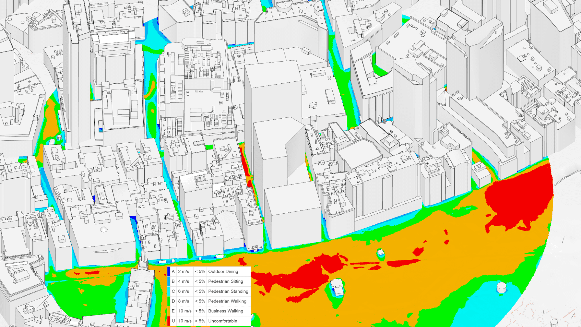
This wind data should be superimposed with the areas where certain activities will be performed (eating, standing, walking, shopping, etc.). The simulation results should then be interrogated to inform what is the root cause of the local wind effects. The major drivers of urban wind acceleration are:
- Downwash
- Tall buildings draw fast air from high down to ped level
- Corner Effect
- Air accelerates around corners
- Channeling Effect
- “Venturi” effect, where local flow restriction between buildings causes air velocity to increase
Now that cause and effect are understood, all that is left is to propose design changes and mitigation strategies in order to meet your functional requirements. These changes can be virtually iterated on all at once, thanks to the power of SimScale cloud platform.
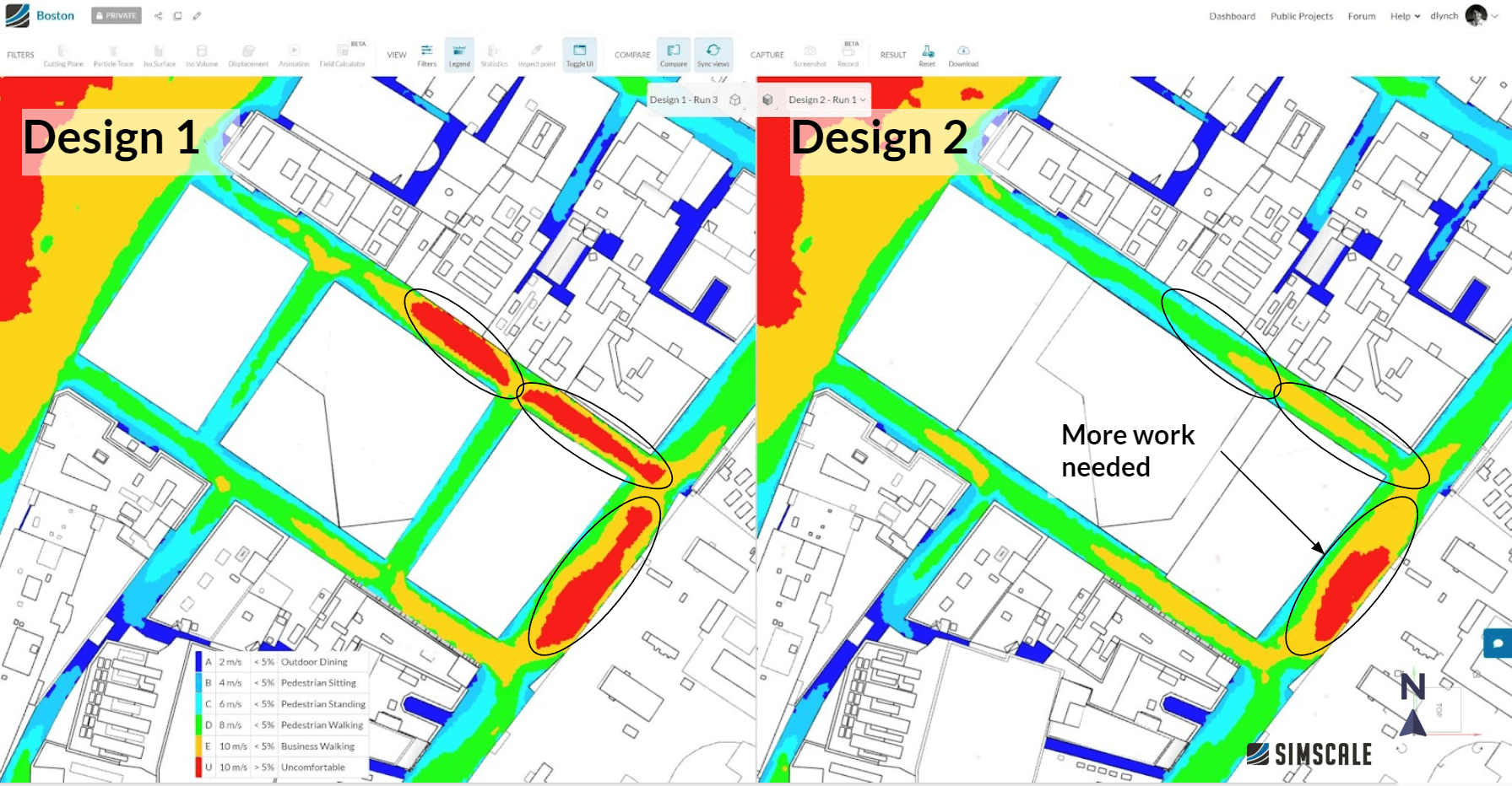
In this Boston example, a glass canopy is proposed to deflect the unwanted high-velocity downwash from the larger building that was identified in the baseline PWC analysis. This simple geometry change was made and the case was quickly reevaluated. As seen in the comparative results below, the canopy was effective at reducing the unwanted high winds in the alleyway on the North side of the building, though more iterating is still required to improve the conditions to the East.
Cities Must Quickly Adapt to a Changing Climate
Just as I witnessed in my trip to Charleston, the urgent need for more sustainable, safe, and comfortable urban microclimates is prevalent in cities across the globe. This challenge can be addressed through the use of the accessible flow simulation capabilities of the SimScale platform. Civil engineers, urban development project managers, and architects can easily and quickly implement detailed wind simulation studies to predict and assess wind effects early on in the design phase, well before the validation and construction stages.
To learn more, watch the Microclimate webinar below: